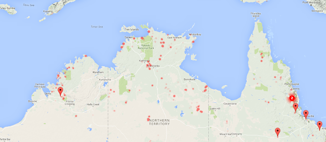
Since I'm no longer connected with departments that produce internal reports on the coming fire season, I really don't have any idea what the forecast for this Christmas is. However, I've just noticed the fire-line across the Northern Territory:
That's a lot of red dots, big enough to be visible from space. Those are not good dots.
And from what I remember with my flawed brain, that staggered line is a trend-setter that continues south in waves over the next few months, as those heat conditions spread.
So, it's probably a good time to consider the history of the Fire Map.
The Past
When I started the map, each service ran their own state incident map (and still do) and I knew that there was no federal agency that had the remit to make a country-wide map. Google had a fairly good relationship with NSWRFS and had just added Victoria, but had no plans to add Queensland or beyond. There seemed only one thing to do...
The Present
Frankly, I've been neglecting the Fire Map for Astromech and day jobs. It just kind of sits there, working away, and really only needs occasional checks and updates when one of the services changes their servers in some way. Fortunately, you can always depend on the inertia of government departments, and I've gone for years without to much issue.
The Future
I'm not sure. I just noticed that the Northern Territory finally has their own incident map / feed, and the perfectionist in me always felt annoyed that there was one big empty chunk on the map. I may have to fix that, at which point the tapestry will be complete.
But long term, the map has no future. I nearly shut it down last year when the hotspots went away for a while, meaning there was no effective difference between my map and the Google Crisis Response map, which has come along enormously in the last few years. I was a momentary expert three years ago, but I really haven't kept up.
I shouldn't be doing this. The only reason I do is because there doesn't seem to be anyone else with the same focus, and the needed abilities.
I'd love to hand it on to some official organization that can form relationships with the state agencies that source the data, and thereby have more warning of server changes than "crap, the dots aren't working today." But that doesn't seem likely either. I once had grand ideas about doing bushfire prediction, (which I still think is very possible) but that was when I had access to data, and the people for whom those answers were relevant.
I'd be interested in advice for what I should do in the future. Is the map still needed?
Update: NTFRS data online
Adding the Northern Territory to the fire map took almost 1/3 of a packet of Anzac biscuits to accomplish (and two years of waiting). That means the map is complete. Every state is on there, making it, truly, the "Australian Fire Map" at last.
Update: NTFRS data online
 |
| It would have to be Humpty Doo. |
 |
| My work here is done. |

No comments:
Post a Comment